
New Mexico is rich with indigenous culture because of the Native Americans who inhabit the land. The Federal Writers Project tours, offered a way to narrate a storyline into each state and define its culture through the objects and places that exist or once existed. Tour 2A from the WPA offers canyons, trails, monuments and mountains. Most of the locations on the map are of Nature and document the stories once told by Native Americans regarding nature. An example of that can be the names of places such as Tunyo, which is the home of a Savayo Giant who ate children from the Ildefonso Pueblo. 1 Mapping this scenario from the WPA established a disguised sense of unity. Discussing and establishing the best places in the state create a sense of unity and organization. While doing this project I realize that this must have been how writers in this project felt. Perhaps they too became overwhelmed and excited to showcase the best regions of their state as a way of showing off to other states as a form of competition, or unity once it was put together. In America First: Tourism and National Identity, 1880-1940 by Marguerite Shaffer discusses how “By combining the nation community by community and state by state for scientific attractions, historic monuments, and literary shrines in surveying the political, economic, social and cultural development in each state, and in documenting the diverse natural settings, the Washington office hoped to capture and codify the richness and variety of the American Nation to enable Americans to ‘rediscover their own country.” 2
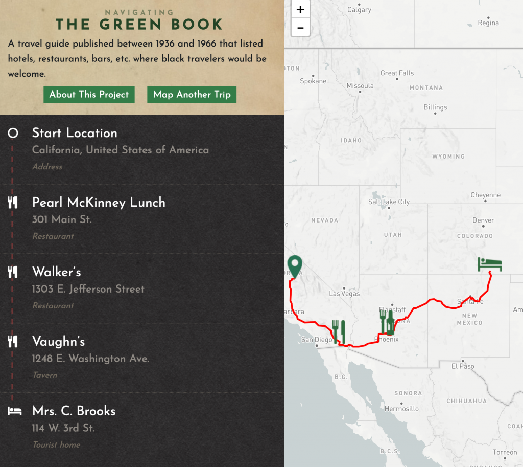
However, this wonderful journey cannot be declared the same for every American. While comparing my map to the map in Navigating the Green Book, the amount of places a person of colored would be able to navigate in New Mexico would be zero. New Mexico tolerated Native Americans, however other races such as Mexicans would often be discriminated against. The journey from California to New Mexico in the Green Books offers only three places to eat and one hotel. None of these establishments fell under New Mexico. This indicates a colored tourist would have no food or shelter in the state of New Mexico. Being able to dissect these maps and include a map that is analyzing racism in 1947 is substantial to analyzing patterns of racism. In Mapping Racism And Assessing the Success of the Digital Humanities by Sarah Bond discusses the importance of mapping racism because ” Data visualizations, now a key part of digital humanities approaches to organizing and visualizing archived records, have in fact long been a (analog) tool used to illustrate the suffering of African-Americans in the U.S.” 3
Although this project helped Americans create a new profound admiration for their country, it failed to include people of color whom were struggling during this era as well. Mapping can help us construct and deconstruct historical time periods in order to understand conflicting positions.
<iframe src=”https://uploads.knightlab.com/storymapjs/7ecb651991299e805365696177de5ede/new-mexico-tour-2a/draft.html” frameborder=”0″ width=”100%” height=”800″></iframe>
- “New Mexico; a Guide to the Colorful State Compiled by Workers of the Writers’ Program of the Work Projects Administration in the State of New Mexico. Sponsored …” HathiTrust. Accessed November 18, 2019. https://babel.hathitrust.org/cgi/pt?id=uva.x000538415&view=2up&seq=394&size=125.
- Shaffer, Marguerite. See America First: Tourism and National Identity, 1880-1940. New York: Smithsonian Institution, 2013.
- Bond, Sarah. “Mapping Racism And Assessing the Success of the Digital Humanities.” History From Below. Last modified October 20, 2017. https://sarahemilybond.com/2017/10/20/mapping-racism-and-assessing-the-success-of-the-digital-humanities/.