
I feel like I learned a lot from this exercise. Originally, I misread the instructions, and set about making a detailed tour map of Norfolk, VA—my hometown—based on the locations recommended by the page that focused on the city. I quickly learned that the locations were too close together to make a good map, and scrapped that project upon rereading the directions. However, it was really unique to be able to engage with my town’s history. I realized that at the time when the chapter was written, half the city’s suburbs had not even been built yet, as the majority of residential housing further away from the downtown area remained farmland until after World War II, when there was a huge housing boom upon the soldiers’ return from war.
Instead of mapping Norfolk, I decided to follow Tour 7a. This spans from Virginia Beach, Va, through to Emporia, which is near the border to North Carolina. Although I have never followed the specific tour suggestions, the route from Norfolk, VA to Emporia is a familiar one to me, as it is a decent manner of navigating into both North Carolina and Tennessee. I feel like mapping this tour gave me new insight into history that I once drove through every day. This mapping exercise has really helped me engage with the history of the region I grew up in, and to form a better understanding of where everything is spatially speaking. The primary sources were really insightful—especially the one which focused on Norfolk. A lot of what was said back then rang true for today as well. There are still mansions on the Lafayette river, working class neighborhoods remain worse-off. The class divide in Norfolk is in many ways still as evident as it was when the tour was designed in 1939, and there are still radicalized connotations to that divide despite the end of segregation. Reading through these write-ups was a truly eye opening experience for me in terms of understanding the problems, not just the successes, of a city I spent the majority of my life living in.
These problems were further brought to light when I looked at the Navigating the Green Book project maps from 1947. There were tons of points and heat map swaths of color all over the country—but Virginia and North Carolina were a dead zone. I cannot help but conclude that there was just cause for this blank space. These travel guides were designed for black travelers during the height of segregation, and being a predominantly rural southern region, the locations along the tour I chose to map were surely less than ideal. As pleasant as the white chroniclers make the sleepy little towns and bustling military cities seem, they were only pleasant for a select group. The sights to see might well be equally enjoyable for white and black travelers alike (Confederate statues excluded), but surely finding lodging, places to eat, places to refuel, etc would have been ten times as difficult for black automobile travelers. I think for that reason, the map screenshot I took is blank. It’s a stark reminder that even today, the beauty of the south and the ambience of small town life mask the darker past that built them. And it deserves to pointed out, criticized, and admonished.
https://uploads.knightlab.com/storymapjs/d56ebb3e141bb0edb0e2e2f71608f8f4/virginia-beach-to-emporia-a-tour-of-virginias-historic-southeast/index.html
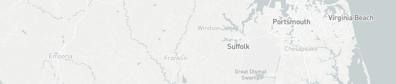
Workers of the Writers’ Program of the Work Projects Administration in the State of Virginia. “Tour 7a.” Virginia: a Guide to the Old Dominion, Oxford University Press, 1947.
“NavigatingThe Green Book.” Navigating The Green Book, publicdomain.nypl.org/greenbook-map/index.html.
