Mapping, Farrey

Creating this map was a very interesting experience. Reading the book was quite difficult as the print was very small and it just wasn’t what I expected. Most modern guide books have a lot more notable tourist attractions, these books didn’t seem to exactly do that. Yes they went into the history of the town and area, but they give little recommendations on what to do there or what there was to see.

Although this assignment wasn’t exactly what I was expecting it definitely was a very interesting learning experience. I definitely agree with Sarah Bond after doing this project. Mapping these historical locations or any point of historical importance can be extremely useful for preserving and teaching history. If anything, these maps are becoming even more important as some of these locations no longer exist due to various causes.

Mapping and Spatial history are extremely important when developing land, by having access to these primary sources we can be able to tell if the land needs to be assessed by an archeological team first to preserve the history of the land. I believe this important skill can really help us to avoid situations that many European countries often face when building. Often times we hear of European countries accidentally unearthing historical site and destroying some very interesting finds, I believe more interest in spatial history and mapping primary sources could prevent that in the United States.

The projects encased in the Green Book collections are only the tip of what we could accomplish with the plethora of primary sources we have. People could even make these maps with online tools like I had done for this assignment. Of course the maps made by the people on the Green Book Project (as seen above) looked much better compared to mine.

The Green Book version of my tour definitely looks more professional then mine and didn’t take the exact path I did, but both versions could be useful. There was one thing I did notice while looking over the Green Books maps though, there was a lot of segregation going on during the times these were made. Most guide books probably won’t take into account that fact and would most likely cater to white Americans.

Travel must have been so much more difficult for people of color during that time. I never even thought about that possibility until I looked over these maps. It really goes to show how different things were back then. Of course black and white travelers could probably take the same route but they might not have been allowed in the same restaurant or get the same quality of service where they went.

That is another reason I appreciated the opportunity to look at the Green Book project, it opened my eyes to that factor. That is something I never would have noticed without looking at those maps, and I think it’s important to recognize the struggles people went through and learn from them. That way we don’t end up repeating the past.

Citations:

 Bond, Sarah. “Mapping Racism And Assessing the Success of the Digital Humanities.” History From Below, October 20, 2017. https://sarahemilybond.com/2017/10/20/mapping-racism-and-assessing-the-success-of-the-digital-humanities/.

“ILLINOIS A DESCRIPTIVE AND HISTORICAL GUIDE : Free Download, Borrow, and Streaming.” Internet Archive. A.C.MCLURG & CO., January 1, 1970. 

“NavigatingThe Green Book.” Navigating The Green Book. Accessed February 1, 2020. https://publicdomain.nypl.org/greenbook-map/.

Blog Post #7

The American Guide Project outlines different topics to include in the state guide. When exploring the Guide To the Old Dominions, I came across societies, folk customs, transportation, and natural resources. According to the American Guide Series, “the guide would convey the “true” America to its people”.

The structure of the Guide To the Old dominions followed the set format stated in The American Guide Series. It focused on the origins of the states and their customs through the lens of a local resident, provides descriptive information about the states like important monuments and wild-life, and lastly, tourism. Which informs readers of the roads, transportation options, major cities and their attractions, natural and historical sites of relevance, and other points of interest to travelers (efn_note)http://exhibits.usu.edu/exhibits/show/americanguideseries/americanguideseries(/efn_note).

Mapping a tour from the American Guide Series compared to that of Navigating the Green Book displayed major differences. During the 1930’s, segregation laws existed in southern states. Due to such and racial bias, African Americans were prohibited to travel in various states causing them find alternative routes that enabled them to reach their destinations. Whereas their white counterparts were free to move from state to state, having unlimited access to restaurants, accommodation and more.

When navigating through the Green Book, I was reminded of the reading the discussed the way in which racism was mapped. W.E.B. DuBois, a prominent African American activists,”traced the routes of the slave trade to Southern states, the value of blacked- owned property…” (efn_note)https://sarahemilybond.com/2017/10/20/mapping-racism-and-assessing-the-success-of-the-digital-humanities/(/efn_note). 
Through these resources, mapping and spatial history tells us much about the pass. It tells a story plotted through space showing  us the scale from one place to another, which involve the use of movement. The two coexist when studying the mobility that took place throughout history. The GIS, a platform for organizing and visualizing data, enhances the ability to examine spatial data (efn_note)https://www.historians.org/publications-and-directories/perspectives-on-history/september-2017/blending-local-and-spatial-history-using-carto-to-create-maps-in-the-history-classroom(/efn_note). Engaging in the process of mapping enables one to think critically about the relationships between the different spaces. Mapping locations enables the use of primary sources to consider spatial relationships in new and productive ways. The use of primary sources spatially provides us with firsthand accounts or direct evidence concerning an event. It allows for research to be conducted, enhancing our knowledge and broadening our understanding.

Blog Post #7-Mapping

The American Guide Series was designed to give shape and language to the various regions of the United States, while both expanding tourism and creating a link between tourism and a more patriotic and American outlook. 1 Through creating a StoryMap, it was interesting see the locations in the state guides come to life through designing a tour that I would create for another person. The Guide Series was written by the people of those specific areas, which brought a more honest component to the information given. This is important for spatial understanding because the locations documented were of interest to the writers while they were still standing, rather than a researcher going back to learn of a monument or area that no longer exists.

               I chose my tour destinations based on the travel of my in-laws from their home in San Diego to their current home in Yuma. Because I would like to potentially relocate to San Diego one day, I chose to look at the project in reverse, looking at historical locations along the way. I felt that the West would have an interesting past and story as we have discussed in class the mass migrations of families to these areas. While reading through both the Arizona and California guidebooks, I looked for tourist stops that would either be of interest to me as I travel, or that would be heavily populated by others. I tried to find patterns in the locations that would help me to develop an idea that could feed into the concept of the ‘American way of life’ in the West that had been a topic in our readings. I had not thought at this point to consider the feasibility of an African American traveler going to these places, and I was shocked to see that their trip would not have been as enjoyable, or even as safe. Based on the various maps from the Navigating the Green Book site, there were almost no locations that were marked green, other than a few restaurant and “tourist homes”. Looking into the Green Book emphasized, to me, the importance of digital mapping to our understanding of history through “reconstruct[ing], preserv[ing], and visualiz[ing components and artifacts] of the past”. 2 This led me to see differently the tour that I had created.

StoryMap: https://uploads.knightlab.com/storymapjs/b8f3f710ff94f8cf5dbd4951f49cbe2e/virginia-a-guide-to-the-old-dominion/index.html

The Sunflower State

The Sunflower State’s first Tour!

The Sunflower state of Kansas is an incredibly rural State set in the Mid-west. I chose this particular State because it seemed like one of the more obscure states that people wouldn’t investigate for social issues. However, just because it’s lower on the totem pole of popularity in tourism doesn’t mean it shouldn’t be examined. Whoever wants to travel there should be able to.

The first tour of Kansas focuses on the most northern cities and towns. They are all close to the border from one side to the next. All these towns are incredibly small and rural, but in the great depression– racial segregation still managed to impact these lesser known areas.

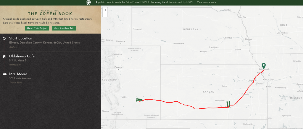
The Tour I mapped was on the top portion of Kansas, but the Green Book shows us that due to segregation someone traveling couldn’t even go on this tour. They would have to to drive all the way to Colorado just to find somewhere to sleep. Due to racial segregation Kansas’ tourism is greatly limited to who it can cater to. They could even travel to the North if they wanted to. They wouldn’t even be able to share the same experiences because racial segregation completely bars them from entering the northern part of Kansas. There is no comparison, because there is no shared experience.

The simple fact that the northern part of Kansas doesn’t have a place for African-Americans shows us through mapping history many things about that area. It is unlikely that there was a prominent African-American population. Even today there’s very little population in those areas, but there is still racial issues. It also tells us that we really haven’t changed enough. The geographical lines of the past are still evident today.

The Primary source of the American Guide Series and the Green Book shows just how small the world was for African-Americans in the Great Depression. How could the project hope to encourage tourism if only a portion of the population could comfortably travel? How could a world in economics disarray not see the full extent of their societal issues? Every generation has its paradoxes, and studying sources like this illuminates how in the future we can avoid these issues.

A Difficult Journey

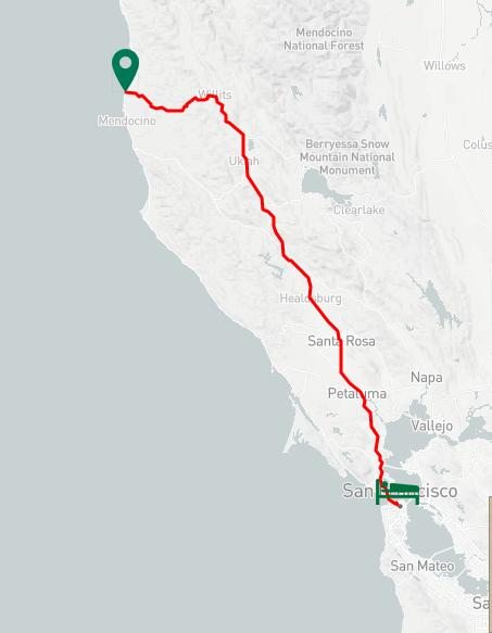
The travel distance from Westport, California to San Francisco is a little over 204 miles long. A journey that encompasses every aspect to west coast life; fishing, lumber markets, farming, and social aspects such as hotels, restaurants and general stores. For a white male American citizen, the trip can be much easier. In the 20th century when racial segregation was still prominent, only white males were allowed to use the railroads in California. With no access to public transportation, the journey from north California to southern California was unforgivable. According to the Green Book project, there are no welcoming stops along this route; meaning that if someone from African decent tried to sleep at a hotel or find comfort in a restaurant for the evening, they would be kicked out. My map suggests that there were many more stops available along Interstate 1 and Interstate 101. From Westport to San Francisco there are 3 major camping grounds welcoming to all because at the time, they were owned by Russian Americans. The Russian Gultch State Park is the biggest and most well known. I was curious as to why the Green Book did not have all of the stops that I found throughout my tour, but it does suggest that some of those places, if not most of them, were not friendly or welcoming to native people or anyone who was not a white male. According to The American Guide Series, white male travelers did not face much adversity along the way but black male and female citizens faced a lot. 3. From not being able to find a place to sleep, eat, or hangout to not even being welcomed into the town, the travel differences between white and black people is immense.

Although San Francisco acquired a large population following the market collapse and the Dust Bowl, this just made jobs harder to get for again, anyone who was not a white male. Asian Americans were very segregated and forced to take the labor heavy, low-paying jobs as were other immigrant races. Using this mapping website, I was able to get a better understanding of just how far away these places are without the use of automobiles for the majority of the population.

The American Guide series was a successful contribution to American history and society. 4. This helped people grasp how challenging it was to be someone other than a white male when regarding traveling or being a tourist. Tourism at that time was plentiful because people were on the move due to the Dust Bowl and market crash. However, this still was segregated. Fishing expeditions were only granted to the white male who had the money and hotels prioritized white people rather than the “first come, first serve” policy.

Overall, this assignment gave me better insight on how people used to travel in the west, what they would encounter, and what adversity they would face depending on who they were. I left out a couple stops along the way because from Westport to San Francisco, there are over 30 places such as beaches, ports, farms, towns and state parks. The important places along this route are the places that I have indicated in my map.

A Cross-Sound Tour: Seattle to Bremerton

https://uploads.knightlab.com/storymapjs/fe6c4b15118e1d99ac23a4974bc0e7a6/exploring-the-puget-sound/index.html

I chose to map a tour in Washington from Seattle to Bremerton. Having grown up in Bremerton and made many visits to Seattle, I was interested to see what landmarks and locations were included in the tour and how they differed from the Bremerton and Seattle that I know. I chose to include on my map a lot of the landmarks that I had personal connections to, some of which I was surprised to learn the history of. The long history of the Navy Yard and Fort Ward did not surprise me. My grandfather worked on submarines and aircraft carriers at the Navy Yard and has always been sure to let us know what a heavy influence the shipyard had on the area; it’s no secret that Bremerton is a Navy town. My sixth grade class actually went on a field trip to the bunkers in Fort Ward where we ran around the tunnels with glow sticks and told ghost stories.

I was amused to see in the Guide that they include phonetic references in order to pronounce many of the Native American place names. It is a long running joke that Washingtonians are well-versed in such pronunciation, as they are commonplace in so many significant place names. The inclusion of the pronunciation instructions in the Guide speaks volumes to the egocentric narrative in which American history is written. It is almost comical in light of the chapter included at the beginning of the Guide on cultural diffusion with “the Indians.”

After comparing my map with those of the Green Book5, I was disheartened to find that the closest location on the Green Book map was nearly 600 miles away in Eureka, California. It may be that NYPL Labs has yet to add any Washington locations if there are any, considering the Green Book map is a work in progress. Regardless, facing such severe limitations on travel due to segregation and prejudice makes this trip impossible for some. For Washington specifically, it is especially enlightening considering how widely Native American heritage is acknowledged in the state, and the glaring hypocrisies that arise with making reparations to one culture that Americans mistreated, while another is meant to be barred from establishments within nearly 600 miles.

La Silve, a “tourist home” in Eureka, California. It is 581 miles from Seattle, Washington.

Digital mapping helps to visualize these hypocrisies and the literal miles left to go to address them6. This spatial history process also helped to picture how distance changed over time. For example, in the Seattle to Bremerton tour, a stop is made in Manette, requiring crossing over the Manette Bridge. This bridge was constructed only 10 years before the Guide was published; before that, visitors from the little lumber village would row to Bremerton. Mapping this distance shows how this tour itself has changed over time.

Tour 2A New Mexico

New Mexico is rich with indigenous culture because of the Native Americans who inhabit the land. The Federal Writers Project tours, offered a way to narrate a storyline into each state and define its culture through the objects and places that exist or once existed. Tour 2A from the WPA offers canyons, trails, monuments and mountains. Most of the locations on the map are of Nature and document the stories once told by Native Americans regarding nature. An example of that can be the names of places such as Tunyo, which is the home of a Savayo Giant who ate children from the Ildefonso Pueblo. 7 Mapping this scenario from the WPA established a disguised sense of unity. Discussing and establishing the best places in the state create a sense of unity and organization. While doing this project I realize that this must have been how writers in this project felt. Perhaps they too became overwhelmed and excited to showcase the best regions of their state as a way of showing off to other states as a form of competition, or unity once it was put together. In America First: Tourism and National Identity, 1880-1940 by Marguerite Shaffer discusses how “By combining the nation community by community and state by state for scientific attractions, historic monuments, and literary shrines in surveying the political, economic, social and cultural development in each state, and in documenting the diverse natural settings, the Washington office hoped to capture and codify the richness and variety of the American Nation to enable Americans to ‘rediscover their own country.” 8

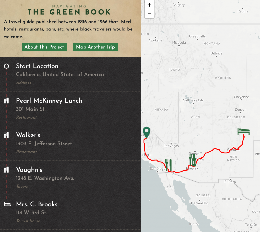
However, this wonderful journey cannot be declared the same for every American. While comparing my map to the map in Navigating the Green Book, the amount of places a person of colored would be able to navigate in New Mexico would be zero. New Mexico tolerated Native Americans, however other races such as Mexicans would often be discriminated against. The journey from California to New Mexico in the Green Books offers only three places to eat and one hotel. None of these establishments fell under New Mexico. This indicates a colored tourist would have no food or shelter in the state of New Mexico. Being able to dissect these maps and include a map that is analyzing racism in 1947 is substantial to analyzing patterns of racism. In Mapping Racism And Assessing the Success of the Digital Humanities by Sarah Bond discusses the importance of mapping racism because ” Data visualizations, now a key part of digital humanities approaches to organizing and visualizing archived records, have in fact long been a (analog) tool used to illustrate the suffering of African-Americans in the U.S.” 9

Although this project helped Americans create a new profound admiration for their country, it failed to include people of color whom were struggling during this era as well. Mapping can help us construct and deconstruct historical time periods in order to understand conflicting positions.

<iframe src=”https://uploads.knightlab.com/storymapjs/7ecb651991299e805365696177de5ede/new-mexico-tour-2a/draft.html” frameborder=”0″ width=”100%” height=”800″></iframe>

A Guide to the Old Dominion

The tour that I chose for this assignment stretched from Hoover’s Airport in Washington DC down to a small town in Virginia called Ashland. I chose this tour because it set in an area that I am familiar with. I grew up in northern Virginia, and I was curious to learn more about the routes suggested by both the American Guide Series and The Green Book. In our reading from Shaffer, she wrote that the American Guide Series had attempted to capture the “real spirit” of the various regions throughout the US 10. Even though I am a native to the area depicted in the tour, I don’t know all the historical and cultural details of the locations. Not to mention, this tour was written in the 1930s, and the guide likely included details that I did not know about.

The tour was interesting enough. I learned a little bit more about the history of several towns that I was familiar with. However, what really caught my attention was the Green Book project. I took the same tour that I had mapped out, and I entered the start and ending points, from DC to Ashland, Virginia. The Green Book route completely stopped in DC, and did not enter Virginia at all. I viewed the US map that listed all the safe locations in the country, and there were none at all in Virginia. 

This Green Book project reminded me of the article “Mapping Racism and Assessing the Success of the Digital Humanities”. In that article, it illustrated the number of lynchings on the US map by county 11. It’s one thing to hear about the number of lynchings in the US, but it is another to see it visually represented on a map. Similarly with the Green Book project, it was quite startling to see that Virginia, my home state, did not have even one establishment friendly to African Americans in the entire state. 

It is saddening as well. A white American would have had little difficulty finding businesses that would accept them on the tour. But an African American would have been unable to find a business friendly to them in the entire state. A simple vacation in Virginia, a tour to see the sights, would be next to impossible for an African American, and there are likely more states that were void of any Green Book locations. Tourism had been encouraged in the Great Depression in order to foster a sense of pride and common culture in the US, but it’s clear that this was only available to a select few.

Tour Map: https://uploads.knightlab.com/storymapjs/28256ced8b3045dd2c400c8dbe9fa0ec/a-guide-to-the-old-dominion/index.html

Tourism Mapping

https://storymap.knightlab.com/edit/?id=virginia-beach-to-west-virginia

Tourism in the 1930s was a crucial aspect in the creation of a unified American culture, different from the regionalism that is still evident today. The promotion of tourism and domestic travel allowed for cultures to clash and mix together to even create new cultures with different blends of an individual’s culture. Segregation made this harder for African American communities during this time because of the social constructs that did not allow them to go to certain areas of the country. Experiences would vary depending on the color of the skin of the traveler but also the region from where they came. Regionalism influenced travel because of the culture that the citizens carried with them but also because of the stereotypes involved with these cultures. Stereotypes may negatively impact the desire to travel to a certain region because of the connotations that region. For example, African American citizens may not desire to travel to the Southern regions because of the cultural values of racism that were so evident during the time. We see another direct example of this structural racism in the maps that W.E.B. Dubois provided during the late 1800s where he mapped the residences of African American communities and the population density of the area.12 These negative connotations may not have proved as relevant to the Caucasian travelers because they would not have seen the direct forms of racism that the African Americans did.

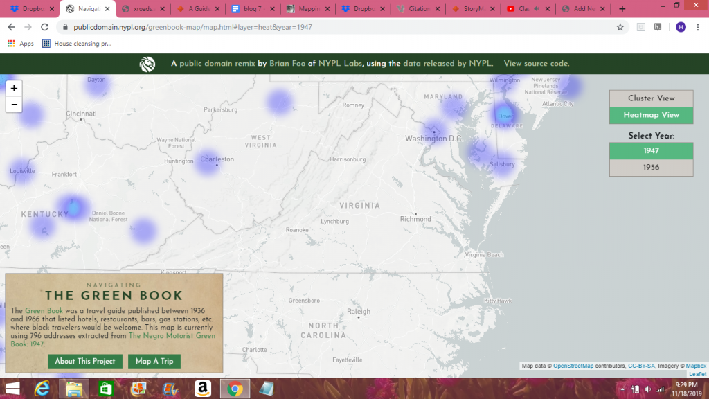
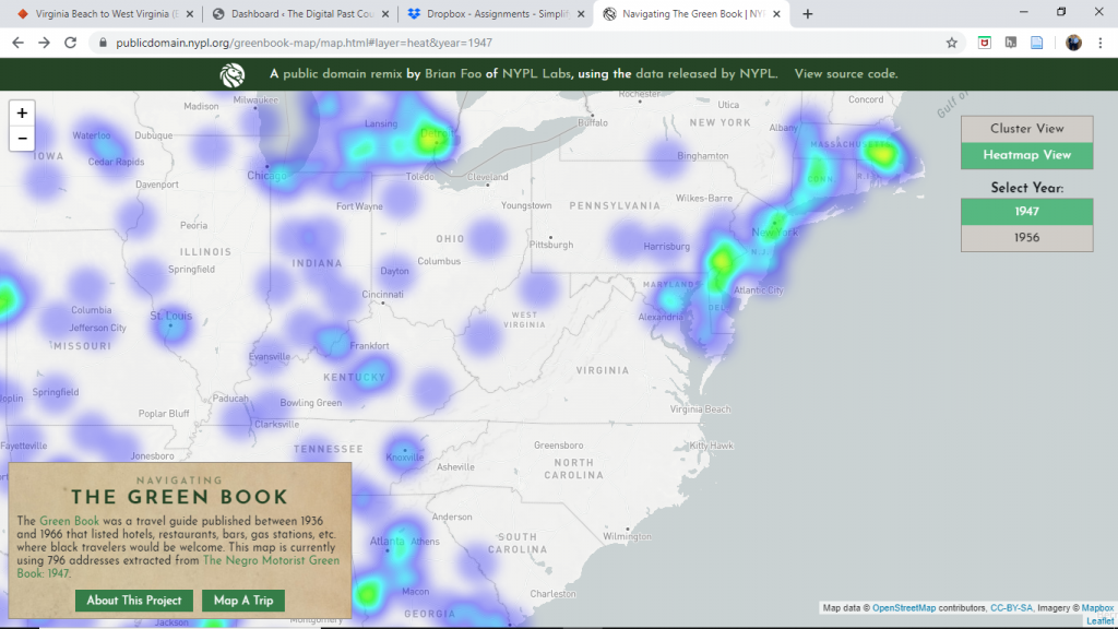
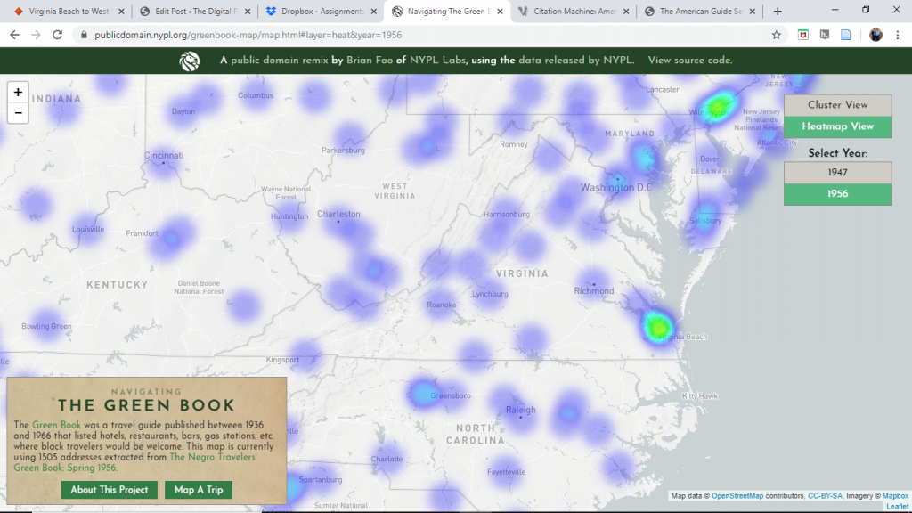
The Green Book shows that the trip that I planned may not have shown too much excitement for the African American population. I expected little heat in the area on the map that represents safety for the travelers however I did not expect to see the absence of safety. The 1947 heat map showed that Virginia did not provide comfortability for the African American travelers at the time. I decided to also include the heat map from the 1950s, although not needed, I believe it shows the transition that America had gone through in the span of a decade. Virginia in the 1950s reflects the transition that the country was going through with the Jim Crow laws. The separate but equal mentality was not ideal for American culture and society however the separation of race could have provided comfort ability for travelers both Caucasian and African American because they could remain within their own cultural bubbles.

In comparison the Green Book, the American Guide provided a list of more physical features of the state rather than a reflection of cultural values that can be see on the Green Book’s maps. From the American Guide exhibit: “it outlines different topics to include in each state guide such as plant and animal life, societies and associations, folk customs and folklore, transportation, natural resources, and many others with the intention of “[increasing] acquaintance with America by Americans…”13 This quote shows the lack of social awareness that went into the creation of this guide. Looking into primary sources of the time may have allowed for the American Guide to provide a more useful guide to traveling that nation similar to the way that the Green Book showed safety for African American travelers.

Exploring the Old Dominion

I have had a few takeaways from this course that will stick with me for a while. They were further emphasized in this skill assignment. Based on previous work in the course, I understood that historical artifacts do not last forever, and their absence and destruction is often notably silent. There were several stops on my tour that no longer existed, despite their historical relevance, and are not even honored with a plaque. Especially as a native of the Washington, D.C. area, I was surprised to hear what used to be considered a tourist attraction. Additionally, I’ve developed an understanding that individuals experience history differently based on their experiences, and the use of the Green Book as a resource enhanced this point. My mapping project can be found here.

The first thing that caught my eye about this project as the transient nature of historical sites in the Washington D.C. area. Among the ten locations marked in my map, the Hoover Airport, Mount Eagle, and Fort O’Rourke have all been demolished. In historical context, not that much time has even passed since these sites were relevant to the culture. They were considered destinations to visit less than a hundred years ago, and each of the sites was established less than three hundred years ago. Given the rapid expansion and modernization of this area during the 20th century, it makes sense that each of these sites were replaced with government buildings, transportation infrastructure, and housing. This also made me consider how historical artifacts will be treated in our new digital age. The nature of historical research is undoubtedly changing14 If something doesn’t take up physical space, but space on a hard drive, is it more likely to be saved? And how do we determine what is worth saving? The Hoover airport wasn’t a commercial necessity. It became obsolete and unnecessary when more airports were established in the area. Why would it be worth maintaining?

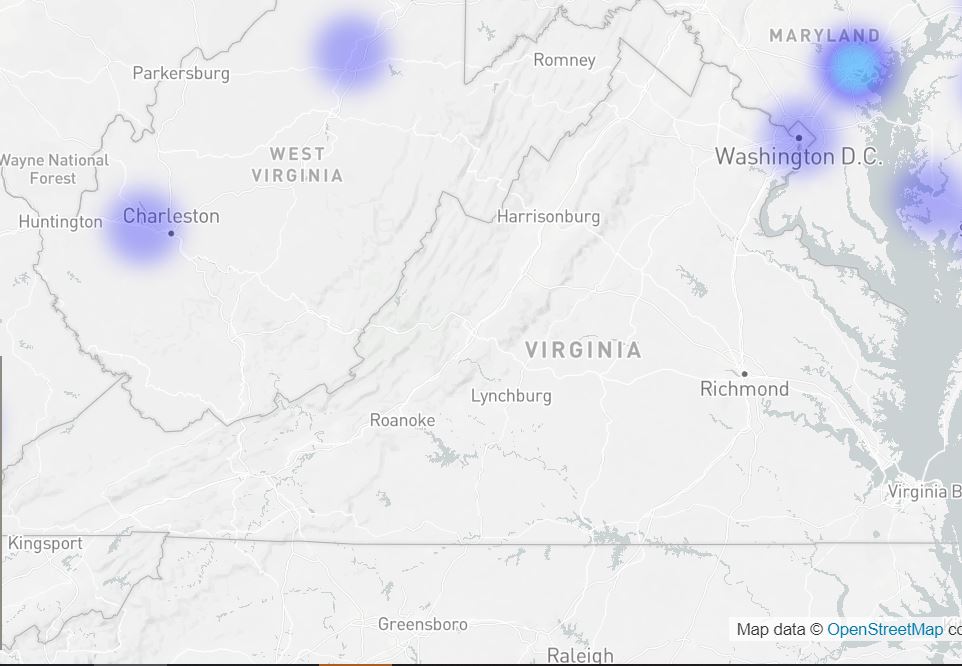
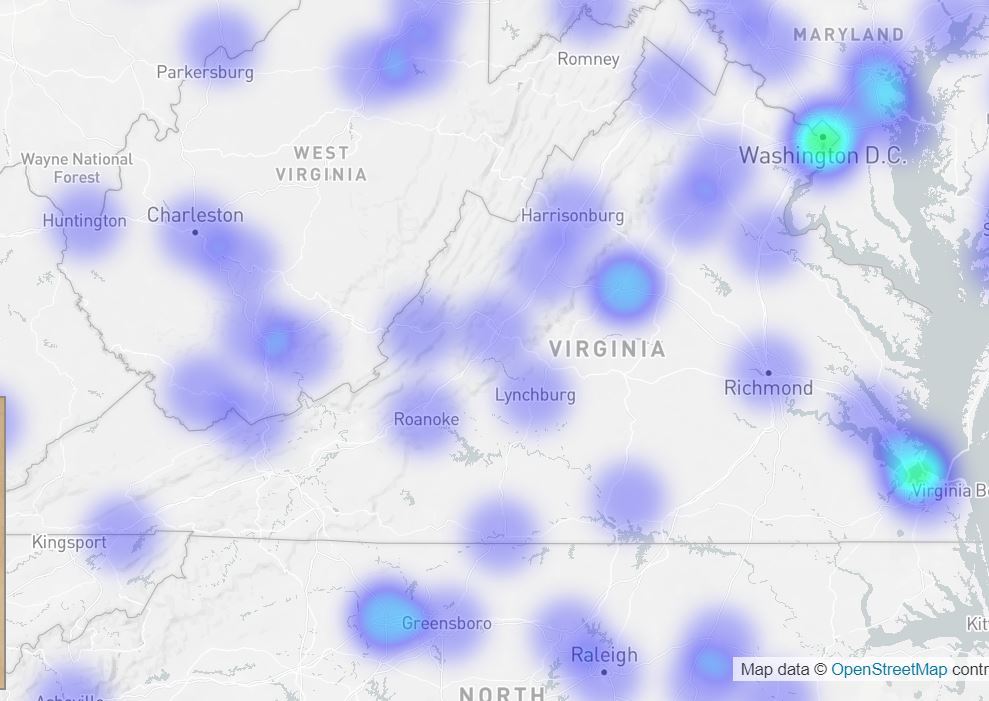
Alternatively, I also considered the role of diversity and perspective in historical preservation and tourism. In the first heat map I developed for this area, there were zero establishments that were marked as being welcome for African American travellers.

Although, this did improve in the succeeding decades. The above map shows information from the 1947 Green Book, while the below map shows information from the 1956 Green Book.

Still, this map is effective, as maps often are15, in helping to visualize and understand the reality of an individual’s existence. That first map portrays the uncertainty that any African American would have regarding tourism in Virginia.

Still, through the destinations provided, it becomes clear that African Americans are not a considered demographic for this guide. Despite discussions of three different plantations in this tour, there was zero discussion of enslaved people, but plenty of discussion about the architecture of said plantations. The focus on these plantations also leads to a situation where, if you’re an African American who doesn’t wish to visit the sites where people were enslaved and tortured for having the skin color that you currently have, the tour becomes unenjoyable.

css.php