The Sunflower State

The Sunflower State’s first Tour!

The Sunflower state of Kansas is an incredibly rural State set in the Mid-west. I chose this particular State because it seemed like one of the more obscure states that people wouldn’t investigate for social issues. However, just because it’s lower on the totem pole of popularity in tourism doesn’t mean it shouldn’t be examined. Whoever wants to travel there should be able to.

The first tour of Kansas focuses on the most northern cities and towns. They are all close to the border from one side to the next. All these towns are incredibly small and rural, but in the great depression– racial segregation still managed to impact these lesser known areas.
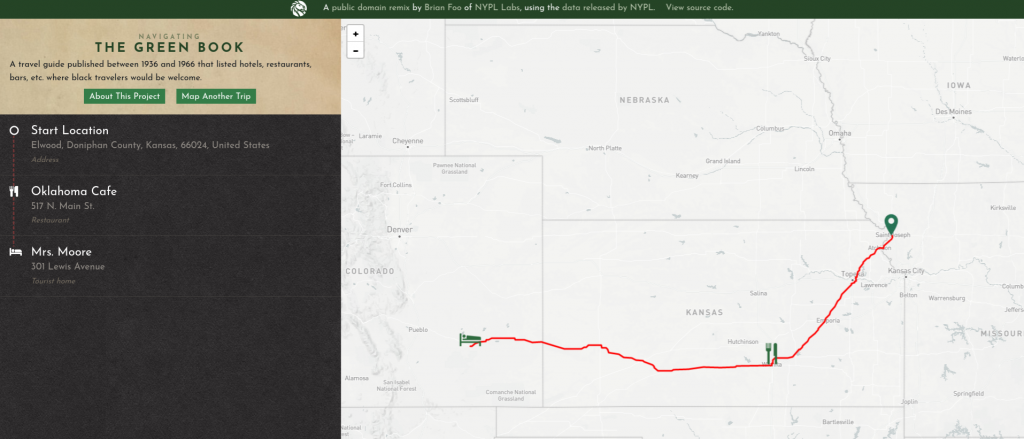
The Tour I mapped was on the top portion of Kansas, but the Green Book shows us that due to segregation someone traveling couldn’t even go on this tour. They would have to to drive all the way to Colorado just to find somewhere to sleep. Due to racial segregation Kansas’ tourism is greatly limited to who it can cater to. They could even travel to the North if they wanted to. They wouldn’t even be able to share the same experiences because racial segregation completely bars them from entering the northern part of Kansas. There is no comparison, because there is no shared experience.

The simple fact that the northern part of Kansas doesn’t have a place for African-Americans shows us through mapping history many things about that area. It is unlikely that there was a prominent African-American population. Even today there’s very little population in those areas, but there is still racial issues. It also tells us that we really haven’t changed enough. The geographical lines of the past are still evident today.

The Primary source of the American Guide Series and the Green Book shows just how small the world was for African-Americans in the Great Depression. How could the project hope to encourage tourism if only a portion of the population could comfortably travel? How could a world in economics disarray not see the full extent of their societal issues? Every generation has its paradoxes, and studying sources like this illuminates how in the future we can avoid these issues.

A Cross-Sound Tour: Seattle to Bremerton

https://uploads.knightlab.com/storymapjs/fe6c4b15118e1d99ac23a4974bc0e7a6/exploring-the-puget-sound/index.html

I chose to map a tour in Washington from Seattle to Bremerton. Having grown up in Bremerton and made many visits to Seattle, I was interested to see what landmarks and locations were included in the tour and how they differed from the Bremerton and Seattle that I know. I chose to include on my map a lot of the landmarks that I had personal connections to, some of which I was surprised to learn the history of. The long history of the Navy Yard and Fort Ward did not surprise me. My grandfather worked on submarines and aircraft carriers at the Navy Yard and has always been sure to let us know what a heavy influence the shipyard had on the area; it’s no secret that Bremerton is a Navy town. My sixth grade class actually went on a field trip to the bunkers in Fort Ward where we ran around the tunnels with glow sticks and told ghost stories.

I was amused to see in the Guide that they include phonetic references in order to pronounce many of the Native American place names. It is a long running joke that Washingtonians are well-versed in such pronunciation, as they are commonplace in so many significant place names. The inclusion of the pronunciation instructions in the Guide speaks volumes to the egocentric narrative in which American history is written. It is almost comical in light of the chapter included at the beginning of the Guide on cultural diffusion with “the Indians.”

After comparing my map with those of the Green Book1, I was disheartened to find that the closest location on the Green Book map was nearly 600 miles away in Eureka, California. It may be that NYPL Labs has yet to add any Washington locations if there are any, considering the Green Book map is a work in progress. Regardless, facing such severe limitations on travel due to segregation and prejudice makes this trip impossible for some. For Washington specifically, it is especially enlightening considering how widely Native American heritage is acknowledged in the state, and the glaring hypocrisies that arise with making reparations to one culture that Americans mistreated, while another is meant to be barred from establishments within nearly 600 miles.

La Silve, a “tourist home” in Eureka, California. It is 581 miles from Seattle, Washington.

Digital mapping helps to visualize these hypocrisies and the literal miles left to go to address them2. This spatial history process also helped to picture how distance changed over time. For example, in the Seattle to Bremerton tour, a stop is made in Manette, requiring crossing over the Manette Bridge. This bridge was constructed only 10 years before the Guide was published; before that, visitors from the little lumber village would row to Bremerton. Mapping this distance shows how this tour itself has changed over time.

Blog #7

When I visited Los Angeles two years ago I did not expect to see the bizarre car-culture frenzy that I did. A monstrosity urban sprawl, coupled with inadequate public transit, made it almost impossible to get anywhere without a car. I selected the Los Angeles Guide because I was interested to see whether the private ownership of a car had always impacted tourism and the ability to move through space in LA. Although the Guide notes railroad stations, bus stations, services, and streetcars, in the general information section of the book, it does not make any reference to them throughout the tours. The Guide assumes that the audience owns an automobile and this implies multiple things. The first is that Guide seems to be created for an affluent audience who owns automobiles and has the time for leisure activities. This is reaffirmed by the landmarks that Tour 6 focuses on, such as a mineral spring, multiple camp sites, and private beaches. But more importantly, the assumption that the audience owns a car also implies that makers of the Guide knew that cars would play a significant role in America’s future. They even note that “the Los Angeles of the future is likely to evolve along highways.” 3

Similar to most other things we have learned about in this class, maps do not offer an inherently impartial and “objective” perspective on history. It’s easy to forget that maps are also manmade and subject to the bias of the creator. Power and privilege must be taken into consideration when using maps and analyzing spatial history, otherwise mapping can very easily become a tool of oppression.

Digital mapping can be useful for historians because “it can allow us to reconstruct, preserve, and visualize vestiges of the past.”4 Mapping Tour 6 on StoryMapJS was helpful because it allowed me to see how the urban sprawl was taken into consideration when selecting points of interest for the tours. Although it was slightly difficult to find the exact locations of certain places because some of them did not exist anymore.

Tour 6 from the Los Angeles Guide on StoryMapJS
Tour 6 on the “Navigating the Green Book” project.

The “Navigating the Green Book” project allowed me to see how compressed a “tour” would have been for an African American traveler in 1947. In comparison to the original tour, which spanned a larger distance, safe spaces for Black individuals would only involve a couple miles between West Hollywood and Central LA, with just three hotel accommodations. The comparison of these two geographic visualizations can be useful in helping people understand how radically different it is to navigate this country in a non-white body. As Sarah Bond argues, digital humanities projects can go beyond “amusing data aggregation” and they can actually create a deeper understanding about the impacts of racism.5

Oklahoma tour guide and Green book comparisons

The state I wanted to examine for this assignment was Oklahoma. My mom is from a small town near Tulsa and I have been to visit many times. Oklahoma always surprised me because it is flat and dry but for some reason I found it beautiful and homey. I chose to do the one in the guide which took people from the Kansas state line to the city of Tulsa. Along the way I choose mainly all big cities and only two smaller stops. I found that many places in Oklahoma were once indian territories and so Indians either still lived around or the place was named based off the tribes. I found it interesting that the Airport in Tulsa used to be one of the busiest airports in the world. I never think people fly through Oklahoma so it surprised me. Another thing I found interesting was the Claremore stop. It was known for finding mineral water that healed people. I looked further into this and saw that there are now resorts there for healing people with the water. 

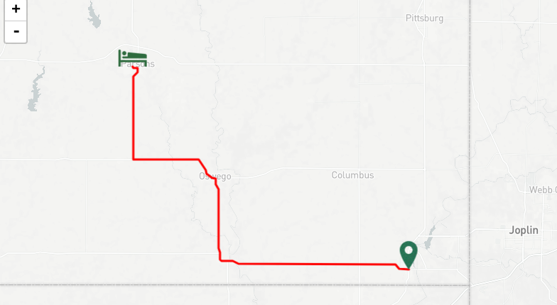
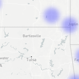
On the green book maps I typed in Baxter springs Kansas as my starting point and Tulsa Oklahoma as the end. I saw that there were no stops along the way that were considered “safe” stops. In the heat map view of the same location there was only some faint blue places but none on my path. I was not shocked to see this because I know that the south was more racist at the time.  I can really see now how “Digital mapping and database construction can allow us to reconstruct, preserve, and visualize vestiges of the past”. I knew the south was a hard place to live and travel for people of color but seeing it laid out on a map and knowing they would have to travel for thousands of miles with no safe place to stop is eye opening. I think seeing it mapped out like this can make a person understand it more. Comparing the Green Book maps to my first map , I can conclude that all of the neat tourism stops were only for white people. People of color would not get to safely experience any of these back then. I think this is interesting because the American Guide series were written to  “convey the “true” America to its people “ and I feel in a way it did but comparing the three different maps conveys more about true America then the single guide.

Bond, Sarah. Mapping Racism and Assessing the Success of Digital Humanities. October 2017, https://sarahemilybond.com/2017/10/20/mapping-racism-and-assessing-the-success-of-the-digital-humanities/

The American Guide Series: American Culture defined: The American Guide Series. Digital Exhibits. http://exhibits.usu.edu/exhibits/show/americanguideseries/americanguideseries

Mulligan, Shannon. Kansas line to Tulsa OK, November 2019. https://storymap.knightlab.com/edit/?id=kansas-line-to-tulsa-ok

Blog 7

These guidebooks were vital to westward bound travelers as there was little other method of knowing the exact routes or ares that one would travel through. There is no luxury of GPS or tourist guides like we have today which exemplifies the importance of these early forms of automobile guides. These WPA guides for regions of the US cover multiple cities on multiple routes while detailing the regions and cities along such route. Schaffer’s book on these guides details how the guides went through multiple reworkings in order to provide the best detailed tour guide of these regions as possible. The wording and structure of the guides seem to make it targeted toward more wealthy people as tourism was not a big industry during this time period. 5


I learned much about the northern areas of Texas by doing this project. The guide provides details on many of the cities and towns that the routes pass through which give a good feel and scope of the area. These maps can tell us a lot about the history of the areas they cover as well as the rise of tourism in the US. These maps also give us an insight to the racial inequalities of the time as well. When making the project map, I noticed that many of the cited cited racial historical events such as native american lands and white expansion into such lands which shows just some of the racial tensions at the time. After comparing my map to the The Green Book one it revealed even more racial inequalities. The path in the American Guide Series was anything but ideal for black travelers. The Green Book path shows that the nearest hotel for colored people to the destination was literally across two state lines. Sarah Bond’s article on mapping racism also shows the same inequalities. She covered how the spatial mapping of racism at the time shows an extra layer to the treatment that these people felt. It also details the multiple kinds of maps that scholars have been working to show these inequalities. 6 . https://uploads.knightlab.com/storymapjs/496d63689e291ecc46a4a31be0418a47/texas-guide/index.html

Blog Post 7: The Empire State

While doing this skill assignment, I realized that the American Guide series seemed to focus a lot on the culture and geography of states, instead of really honing in on issues. This statement, however, only really applies to the New York American Guide from 1940 because this is the one that I analyzed and used for my map. For actual research purposes, I would have to read multiple guides from different states to see what those writers and editors chose to emphasize on. No matter what the state, like Marguerite Shaffer quoted in her See America First: Tourism and National Identity, 1888-1940, all guides sought out to attempt to create a “‘literature of collective of self-consciousness, a people’s and a nation’s biography, a story of human and physical geography.’ In both its scope and design, the WPA American Guide series manifested this desire to document and design a unique and indigenous American culture” (Shaffer, 2001, p. 203). 7

In the “Navigating the Green Book” feature by the New York Public Library, I was really surprised to see so few establishments available for people of color in 1947. I was expecting to see a lot more locations open, especially in the North. While looking at it, I thought to myself about how Victor Green went about receiving information about these different establishments. Perhaps, there were more that catered to Black customers, but Green simply didn’t have that knowledge in 1947. In comparison to the 1956 map, the 1947 one seemed to unfortunately lack, in my opinion, enough places to service Black Americans. Seeing the 1956 map made me consider whether or not establishments were moving towards a more tolerant and progressive business structure and started to allow Black people into their stores, or did Green simply learn more information over the decade. In Sarah Bond’s article, “Mapping Racism and Accessing the Success of the Digital Humanities,” she talks about the fact that “people of color have been using maps to visualize racism for a long time,” including W.E.B DuBois and Booker T. Washington in the late 1800s and early 1900s (Bond, 2017, p. 1). 8 I think the Green Book series in a way is a continuation of this trend set by prominent Black activists to show America how racist and detrimental it is towards people of color.

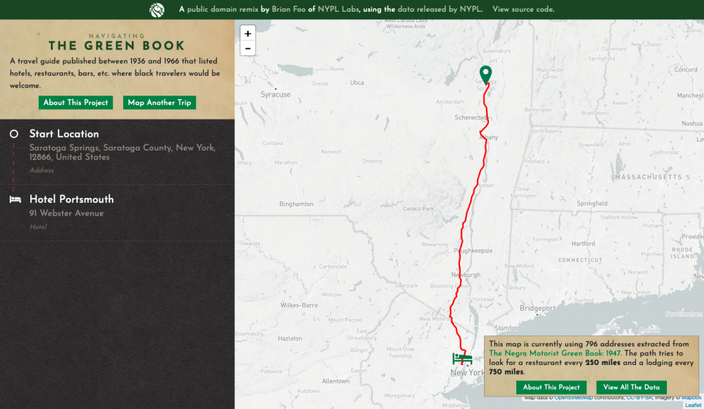
I chose the American Guide to New York titled, “New York: A Guide to the Empire State.” I mapped out Tour 21, which featured locations starting in Montreal, Quebec, Canada and ending in New York City, NY. What I found from the coverage of most locations was that the writers tended to focus on the geography of these specific places. Information about the state itself was featured in other sections. The Tour barely talked about the present-day, as in 1940 when the guide was written, locations and the people who inhabited them, but rather the locations in a historical context, as well as their relation to highways and local routes. This is a big contrast to the Green Book. The Green Book didn’t feature as many locations and it only strictly focused on culture (restaurants, lodging, etc.) and not history. There’s history to be found in both, though. In looking at these books, it’s easy to decipher treatment of ethnic Americans at the time. At least for the New York American guide, foreign-born, Black, and Native Americans are all spoken about statistically, and if not statistically, then either not at all or simply blown over. However, the Green Book is essentially always radicalized. Although it’s just a map with safe places for Black Americans to stop on their travels, it’s a historical statement over the fact that guides like that existed in general.

Going off the Road

Beginning this assignment, I immediately knew what state I wanted to look at. Maine has always interested me, so I thought this would be the perfect time to get my feet wet. The tour I chose was Tour #4, From Fort Kent to Mattawamkeag. Now the focus of these tours was mobility and creating a good sense of the state for tourists. This tour intrigued me because it sounded mostly “off-road.” Trails and canoeing down rivers were always mentioned at some point along the way. This tour was not for the faint of heart; rather, it was for those seeking sport. There was no road to simply drive down and sightsee, this route went through the woods and often junction with State Route 11 at certain points. I interpreted this as the writers wanting to show off the wilderness of the state, show what fun it has to offer in lush scenery and hard-working people.

The interesting thing about the tour is that it runs north to south almost in a straight line. Marguerite Shaffer’s See America First: Tourism and National Identity, 1880-1940 states that the federal workers wanted the tours to not be cyclical, but to go in the cardinal directions from state border to state border. 9

This tour offered many surprises when compared to the Negro’s Green Book project which compiles data about trips blacks took to safe spots for them in the past. Being that this tour was organized by the government and carried out by the state and local governments, this tour was mostly in the hands of White Americans. This image, screenshotted from Google Maps shows the general path of the Fort Kent-Mattawamkeag Tour. While traversable today, White Americans would most likely have enjoyed the thrill of the sporting events (hunting game and fishing) and taking to the wooded trails and canoeing. This map, created from The Green Book‘s data in the year 1947, shows a path that does not line up with the tour. What I feel this shows is that they (the Blacks at the time) would not travel through the forest trail or down State Route 11 to get to Bangor. This shows that these small towns might not have held the same importance to White Americans as it did to Blacks. Here, I think a historical bias could be drawn, but something else needs to be looked at first.
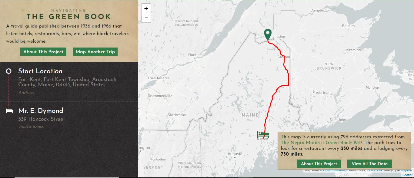
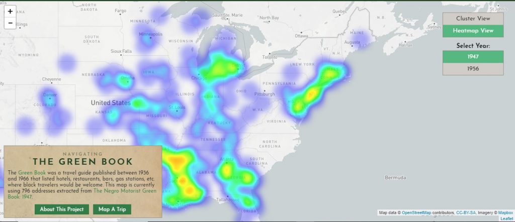
Heat Map (Density Map) showing the prominence of safe spaces for Blacks in the year 1946. This view is specifically of the East Coast and Midwest.

Using this heat map, it is easy to see that Blacks in Maine was not a common occurrence. There was only one rest stop available for them in the city of Bangor and not much else. No matter how I planned the trip, everything always ended back up at Bangor. So, concerning the historical bias 10 of the tour, nothing really reflects a racist attitude towards blacks as they were not a heavy presence. A lot of the major cities like New York, Chicago, and Atlanta are more densely populated by such locations that it makes sense as Blacks were more common to those regions.

By taking these tours and analyzing them both digitally and spatially, the goals of the FWP in writing the guides become apparent. Maine is rich in wildlife and game, making it a choice place to visit for hunting, fishing or for beginning a lumbering industry. The concept of wanting quasi-linear tours is also apparent. Maine has it all to get tourists coming to its forested frontiers. In a similar vein, The Green Book shows the racism of the times and the places blacks could go. It evinces a sense of a broken nation that really clashes with the goals the New Deal Administration wanted to bring in.

Alaska

https://uploads.knightlab.com/storymapjs/5b0a1b53c05106520621c0f260f751f8/alaska-a-guide-to-the-last-american-frontier/index.html

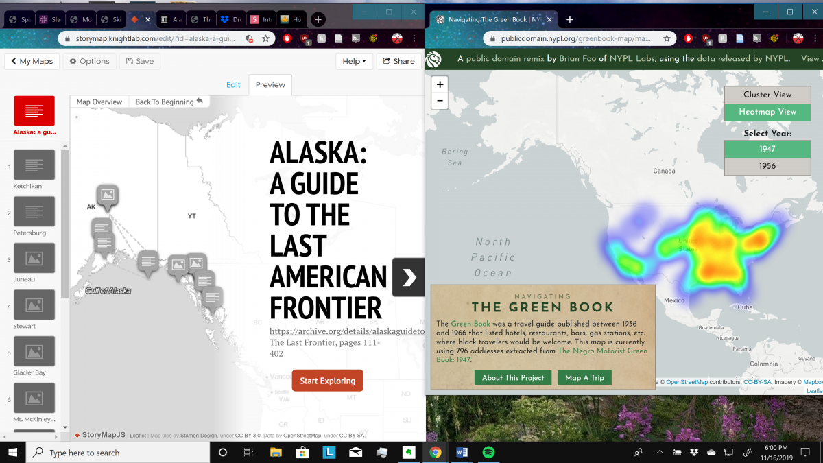
What I planned for this project was to use the data of the Green Book Project to find out what mobile citizenship looked like in a place as remote and physical as Alaska, if there were accommodations for coloured hikers within the territory. However, the Green Book Project showed no data whatsoever outside of the mainland United States. This makes sense; in a state such as New York or Pennsylvania, you could take a tour and theoretically never leave your car. This is impossible in Alaska, due to the lack of roads. To access the capital, Juneau, even to this day you must take a ferry or a plane since there are no roads leading into it. Alaska is a destination attractive for its hiking, first and foremost, and one would be hard-pressed to drive there.

We can infer information about Alaska from similar states known for hiking and northern climates: Colorado and Washington, respectively. By the looks of the reports from the Mapping Inequality Project, it appears that black populations were not much more liberated there than in most of America; of one prominent black district in Denver, the surveyor writes, “For a Negro section, it is very well kept up. Were it not for the heavy colored population much of it could be rated ‘C’.” He rates every coloured section of Denver similarly. Regarding black residences in Seattle, the surveyor simply wrote “This is the Negro area of Seattle”, and ranked it a D. Considering the echoing ramifications of these reports, it seems reasonable that black people were precluded from the free time and capital required for serious hiking. 11

The improved mobile citizenship the Green Book promised in the 1940s did not apply to a more active brand of tourism. One look at the Green Book Project, and one can see that lodging for the more mountainous regions is sparse, ranging from five in Colorado to one in Montana and none in Washington. I believe that a perfect storm of decreased institutions for black people (evident in low coloured populations in those areas) and simple incapability of travel to mountainous locales led to this dearth of trail lodging in popular hiking destinations, conclusions which can be extended to Alaska.

By all means, mountain hiking was restricted to white tourists. Tourism as the “ritual of citizenship” so cherished by many would be null and void when it came to experiencing natural wonders up close, excluding me from the beauty of the country I want to be a part of. If I were a black traveller, the infrastructure simply would not be there to preserve me from humiliation and discomfort were I to hike in Alaska. This wouldn’t be just nothing, as “the 1930s might best be characterised by a pervasive interest in culture… the more anthropological concept of culture denoted by a shared set beliefs and behaviours”– and the pool of these shared beliefs and behaviours would shrink all the more with my myopic access to hiking in America. 12

Blog 8

Archives such as the Special Collections Research Center offer scholars chances to engage with the materials and information that they focus on. It provides a place for those documents and unique pieces of history to be preserved and used for historical pieces later. Preserving these pieces of history and storing them so that they may be called upon again is why archives are extremely important. In an interview, archivist Elvia Arroyo-Ramirez stated that record creation, keeping, obstruction, or misrepresentation are all acts of identity and power. This is why she is proud to do the work of preserving the voices of the people who created those works of art. 13 Archivists preserve and record these works of art that often give voices to those who often go unheard. These special collections allow the public to hear from these people in unique and specific ways that most historical information doesn’t allow for.


Archivists must decide which materials to be digitized and this decision stems from the condition of the piece of work or art, ability to be scanned and uploaded, space for data to be stored, and importance of the work. After taking all these into consideration, they must decide if it is worth being digitized. Digitizing these works does allow for more accessibility as we are in a world that revolves around technology and being able to access information form anywhere, but there is something about experiencing works in person especially art that viewing on a screen just cant compare to. That digital information however, does allow for the voices of those artists to reach multitudes of people.


The Federal Theater Project had a deeper impact on the United States than I had originally thought. We can see from the introduction of Peter Grough’s book on the New Deal and Federal Theater Project that music was often the only thing some of these people knew and fostering that and giving a channel for them to grow that exposed them to new ideals and skill that changed their life. 14 The project gave many people jobs as music teachers as well as giving people music programs to participate in and uplift their lives. Many people cited the music projects in the west as the reasons for pulling themselves out of their slumps and giving them purpose. The true importance of the Federal Music Project was lost on me and these readings help me to realize that.

Archive Reflection

In class this past week we explored interesting artifacts that George Mason has kept secure since the 1930s. In groups we were asked to examine notes written or typed in scripts from shows produced by the Federal Theatre Project. I found them extremely interesting because looking closely at handwritten notes by a director or member of the crew spoke volumes about the intentions of the production. For example, a group shared that their director took notes that the electricity stopped working during a production called Power. Another one shared the director made a notes that the actors needed to act more southern and another shared notes on how they were trying to get their production advertised but found some difficulties. All of these notes can make a reader understand the productions and society at the time better. Without saving these notes people would think all the plays went rather smoothly and the difficulties they faced wouldn’t be known. The information on the productions left by notes and kept safe is so important because it makes people understand the struggles the Federal Theatre Project faced. 

The archive collection at Mason is huge and although I was unable to attend the seminar I have a friend who works there and I was able to hear a little bit about what they store there, and how they store the information. 

I thought the reading and learning about digital archives was interesting because I always wondered how, why and to what purpose saving something digital could be as important as preserving something like a photograph.  In The Artifactual Elements of Born-Digital Records, Part 1 author Susan Manus touched on the changing technology. Looking back technology has changed immensely and being about to keep “antiquated carriers can also serve distinct roles in digital preservation activities” which is something I never thought about.Being able to look back onto something from one of the first computers would open up a whole new idea to you then just reading about it. 

In the interview between Thomas and Elvia, Elvia touches on her interest in archives and the topic of how people decide what is important enough to  preserve. In the interview it touches on how Elvia grew up bilingual in America and so she can relate to artifacts about cultures and is able to distinguish the useful ones. Also Elevia states that there are “ Issues of representation and power are fundamentally rooted in archival work “ and because of this people challenge archival neutrality. People in the archive work need to remain neutral in order to preserve important information. Elevia says she tries to “have conversations across similar fields with a diversity of practitioners is key to understanding how our practices and end goals are alike and dissimilar”.

Manus,Susan. The Artifactual Elements of Born- Digital Records, Part 1. (November, 2011). Library of Congress.

Padilla, Thomas. Elvia, P. Bias, Perception and Archival Praxis. (September 2013). Data Praxis

css.php